Oil & Gas Exploration
AGI Surveys for Oil and Gas Exploration, are used to explore for gas, condensate, and oil hydrocarbons, both onshore and offshore, in all terrains, geographies and climates. AGI’s unique technology has been used in over 70 countries with climates ranging from frozen tundra to dry desert to tropical jungle. It has been used to derisk frontier exploration, maximize production in field development, map hydrocarbon charge in areas with limited seismic clarity such as thick salt sequences, channel sands, or thrust belts, evaluate fields with heavy oil or stacked pay, and define sweet spots with enhanced porosity, pressure and hydrocarbon richness in shale plays.
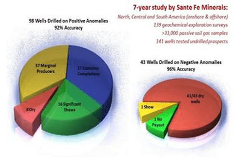
AGI surveys, proven with 92% prediction accuracy and 58% cost savings, deliver smarter exploration results worldwide.
Traditional Methods
Many traditional methods have the benefit of being inexpensive screening techniques that in some cases can detect near-surface gas or liquid hydrocarbons. However, these methods aresubject to a lack of sensitivity and specificity, and consequently have higher false positive and false negative rates.
In addition, these older technologies do not work well in stacked pay scenarios, lacking the capability to discriminate and differentiate hydrocarbon signatures from multiple formations or depths.
AGI Methods
- it is a direct hydrocarbon measurement method (thus it is not subject to interferences or false positives from near-surface soil conditions as are indirect methods),
- 1,000 times more sensitive than other methods
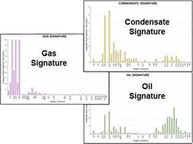
- measures over 100 compounds from C2-C20, providing a unique ability to clearly define and differentiate multiple gas, gas condensate, and oil signatures,
- has a >90% success rate at predicting dry hole, thus reducing exploration risk and drilling costs,
- can clearly differentiate between multiple gas, condensate, and oil signatures,
- can identify stacked pay and multiple petroleum systems.
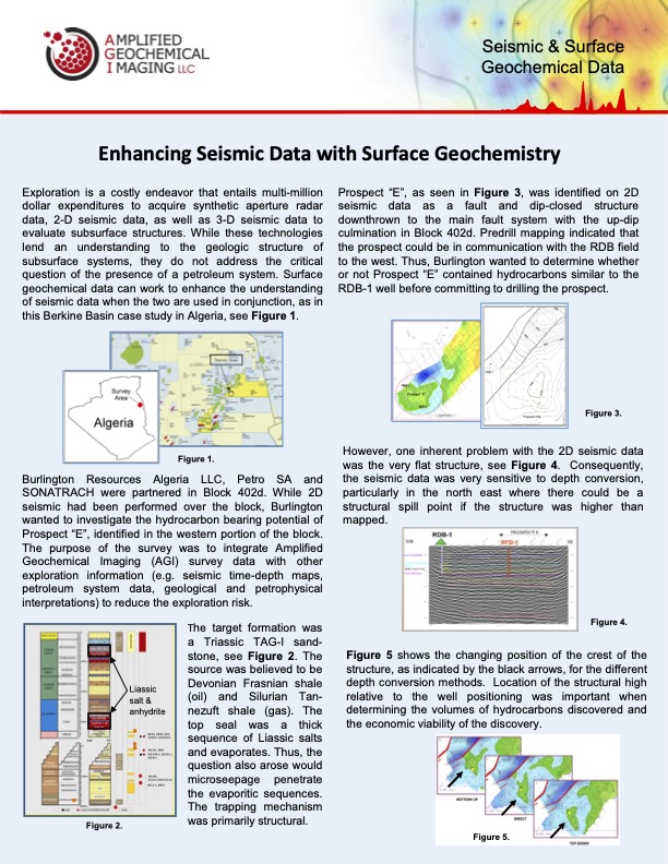
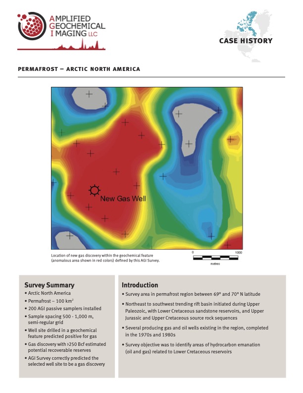
Case History
For Exploration and CCUS Information & Quotes :
Download our Exploration Services Analytical Options.
Download PDFFrequently Asked Questions
The main reason is the volatility of hydrocarbon compounds – C20 is the approximate limit of semi-volatile behavior, beyond which hydrocarbon compounds do not partition into the gas phase to an appreciable amount. The AGI Passive Sampler uses adsorbents that provide very good capability for volatile and semi-volatile organic compound collection. These sorbents are encased in a permeable membrane with >80% open area and pores about 1000 times larger than a C20 molecule. If the compound does not partition into the gas phase, it will not pass through this membrane to reach the sorbent material.
Normal and branched alkanes, cycloalkanes, alkenes, and aromatic hydrocarbons predominate, but our current target list of approximately 90 compounds also includes certain terpenoids, furans, aldehydes and some sulphur compounds. Although physical property data for compounds above C6+ indicate that at standard temperature and pressure (STP) (or near surface conditions) these compounds are in the liquid phase. Each exerts a vapor pressure and thus vapor phase constituents of these compounds are always present in soil gas or at STP. By way of example, styrene, xylene, and diesel are all liquid at STP, but each exert a vapor pressure that allows detection by their odor. Thermogenic compounds in liquid phase at STP have been measured in surface soil gas separating them from Recent Organic Matter (ROM) signatures.
The list of volatile and semi-volatile organic compounds reported by the Amplified Geochemical Imaging Exploration Survey is purposely broad in scope, so as not to disqualify compounds that might have significant, yet unknown, correlation to petroleum emanation. Since the interactions and reactions of hydrocarbon compounds at the surface are not well understood, any selective bias would risk the exclusion of potentially important compounds, and could result in a service that is not as powerful in the delineation of petroleum prospectivity.
For most cases, it is preferable to use fresh undepleted reservoirs or wells for modeling because the surface signal declines as reservoir pressure and thickness decrease. However, there is insufficient evidence from past projects to develop specific rules on minimum reservoir pressures for proper modeling locations. The current guideline is to select the best available productive well sites for modeling purposes. Depleted signatures can be differentiated from dry hole signatures, and if a depleted well is modeled, a depleted signature model will result. Obviously, the geochemical anomalies identified by such a model will represent depleted conditions. This sort of model result may be sufficient to meet certain survey objectives, perhaps involving the mapping of reservoir charge versus no reservoir charge. Another benefit to using partially depleted wells is to confirm areas with lower productivity especially in field development.
AGI Exploration Survey is a model-based method. Samplers placed near production well sites are used to define the character of hydrocarbon emanation, while samplers placed near dry well sites are used to define the character of geochemical background. The samplers selected for model development are then assumed to represent the essence of petroleum emanation (from subsurface accumulations through to the surface via vertical migration microseepage). If this assumption is valid, then the model reflects subsurface signature and the model results (in the form of anomalies) indicate places where the same conditions prevail. Fault signatures should be significantly different than vertical migration microseepage. Fault seepage involves the mass movement of fluids along continuous pathways from the reservoir to the surface, while microseepage involves the movement of hydrocarbon molecules through microscopic pore spaces and along mineral grain boundaries. Fault signature typically shows enhanced response for heavy hydrocarbon compounds as opposed to a typical microseepage signature for hydrocarbon emanation. Therefore, our results have no comment on the condition of fault migration in the survey area, as our modeling does not proceed from a fault emanation signature. There may be significant fault leakage, but the chemical profile of such seepage would be different from the model of microseepage emanation and would not be shown as anomalous. On the other hand, faults can often be identified or inferred from the chemical signature or from the mapped anomalies.
No – source rock signatures do not appear to mask the emanation of reservoir hydrocarbons at the surface. Organic compound emanation from source rock beds with high total organic carbon (TOC) content yield a distinct signature from reservoir petroleum signatures at the surface. An extensive source rock bed may in fact contribute to the regional background geochemical signature. The interpretation of AGI Exploration Survey data includes techniques used to discern various geochemical signatures, including regional background character.
The influence of shallower (biogenic) hydrocarbon sources can be filtered out of interpreted results through the appropriate modeling of deeper thermogenic accumulations. The geochemical modeling process developed for use with AGI Exploration Survey data allows the discrimination and separation of such undesirable influences.
An analogy would be comparing the price of 2D seismic to 3D. In fact we are higher than other methods because we are the only method that can not only detect hydrocarbons, but we analyze for compounds from C2-C20. Other methods only analyze C1-C5 alkanes. This broader detection range allows us to differentiate between “background”, oil, gas, and condensate, and delineate charge boundaries. This provides our customers with the most accurate analysis possible for reducing exploration risk.
In fact, we only employ a crew to travel to the field one time. Deployment and retrieval is scheduled such that as the last point is installed, it is time to go back to the first point installed and begin retrieval. This insures that the crew is only mobilized once.
We try to schedule the whole deployment and retrieval process to take place within about 25 days or less.
All samples are installed with accurate GPS coordinates and under the supervision of a skilled field supervisor. Our retrieval rate for over 2500 surveys in the past 10 years is above 97%.
Our sampling method allows deployment in all types of terrain including swamp or transition zones. We have conducted numerous surveys in swamp locations all over the world successfully. The GORE-TEX® membrane allows direct sampling in water depths to 30 feet without harmful effects or contamination. (GORE-TEX ® is a registered trademark of W.L. Gore and Associates)
Our research indicates that exposure beyond the recommended exposure period of 17 days does not substantially change the mass or chemical composition detected. Samplers left in the field with exposure times of 20, 30, 60, and 90 days were within a 98% correlation coefficient.
Connect with us.
US Offices
COLORADO - Corporate Offices
7625 W 5th Ave, Suite 206N, Lakewood, CO 80226
DELAWARE - Laboratory and Manufacturing
210 Executive Dr, Suite 1, Newark DE 19702
TEXAS - Branch Office The Greater Houston Area
International Office
INDONESIA C/O PT GEOSERVICES
Jl. Minangkabau Barat No.34
Jakarta Selatan 12970